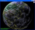
Global Weather 3D lets you check how the heavy the clouds are at any point on the planet through a 3D representation of Earth. Layers are drawn over the model to represent the position and density of the clouds.
The program takes meteorologic information from Google and can be updated manually through the program's options menu.
Advertisement
Other layers included in Global Weather 3D let you see country borders, main cities, real-time day/night, time zones, etc.
You can use the zoom to get closer to a specific area and activate the "colorize clouds" mode to see cloud density in red, yellow, and purple (for most dense).


Comments
There are no opinions about Global Weather 3D yet. Be the first! Comment